New MapRender version 0.7 released

The new MapRender 0.7 version is released and comes with these new features:

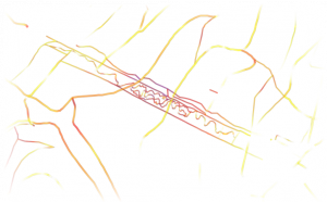
  • New Renderer to create a Schummerung based on the angle of a slopes. It is mainly useful in combination with the high resolution height data from the Landesamt für Geoinformation und Landentwicklung Baden-Württemberg (LGLBW).
  • New feature for the height color renderer: up until now it was only possible to represent the absolute height of a pixel by applying a given color range. Now it is also possible to represent the relative height compared to the surroundings of the pixel. Both new renderers can be combined to show highly detailed ground features that would otherwise be hidden.

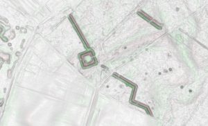
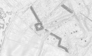
    As an overlay over a default rendering of the OSM-data this significantly enriches the map compared to the standard version of the map:
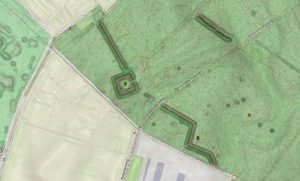
  • Improved the performance of the renderer in the job- and zoomlevel-transition phase.
  • Several Bugfixes

New MapRender version 0.6 released

The new MapRender 0.6 version is released and comes with these new features:

  • New importer for height-data provided by the Landesamt für Geoinformation und Landentwicklung Baden-Württemberg (LGLBW) under the OpenData iniative.
    This data has a high resolution of 25cm horizontally and is based on the real ground height without trees or buildings. The vertical resolution has an accuracy of 15cm.
  • New renderer for color-coding the slope angle of streets. This can be rendered as a separate layer to be used as an overlay over an existing map (e.g. here) or directly integrated into a map (e.g. here).
  • Several Bugfixes

New MapRender version 0.5 released

The new MapRender 0.5 version is released and comes with these new features:

  • MapRender now additionally supports the Mollweide- and Albers-Projections besides the standard Mercator-Projection:
    • Mollweide-Projection: an equal-area map projection that displays the world as an ellipse.  This projection focuses on the  accuracy of the area proportions at the cost of the accuracy of angle and shape.


    • Albers-Kegelprojektion: an equal-area map projection that projects the world on a cone. It focusses on minimal distortion between standard parallels at the cost of  the scale and shape of geometries.


  • Dynamic scaling of parallel threads depending on the number of available CPU cores, assigned RAM and memory requirements of the current job threads.
  • Several Improvements
  • Several Bugfixes

New MapRender version 0.4 released

The new MapRender 0.4 version is released and comes with these new features:

  • Several Bugfixes
  • Support for CDATA placeholders in the color attribute of the LineSymbolizer and ShieldSymbolizer, enabling the use of colors coming from the OSM database.
  • Logging now happens at the end of each tile rendering cycle.
  • Shutdown of the database connections and the embedded jetty server now happens after the last rendering thread has finished not after the last rendering thread was queued.
  • Export to SQLite database now supports adding multiple distinct rendering runs into the same SQLite file.

admin

06.07.2020

Due to the need for a better maintainability this site has moved to WordPress landing page.